Wednesday, August 06, 2014

Mission Peak Hike

Not all of our adventures are on the bikes, but they are adventures never the less they are fun


Couple of days ago Tiffany came up with a great idea of climbing up Mission Peak in order to be able to experience and photograph the view above the clouds.
Being that it is summer in Northern California and temperature has tendency to rise on average above 100's by mid day, we had to get up early enough in order to be at the trailhead at Ohlone College in Fremont CA, by 05:00 AM when the trail officially opens for a day. This location has plenty of parking spaces at the price of $2.00 during the weekday and it is free of charge during the weekend.
There are several other options of accessing trail system that will eventually take one up to Mission Peak, most known is at Stanford Avenue. Unfortunately this location has been used so often by to many day hikers and trail visitors that it has become a problem and nuisance for people living in its vicinity of the trailhead. Authorities are quoting that on average weekend close to 6000 people visits this Regional Park.


As one can see on the map above, reason why so many day visitors prefer Stanford Ave. access point is shortest distance from ones vehicle to the Mission Peak 2.2 Miles (3.5km), where distance from Ohlone College is close to 5.5 Miles (9km). However trail from Stanford Ave. is significantly steeper than from Ohlone College.
Noelle and I walking up the Peak Trail passing some of cattle fence

Also another benefit to starting at Ohlone College is the fact that there are a lot less people using these trails and therefore you get to enjoy natures quite solitude. After all that is what most true nature lovers seek when they go outdoors.

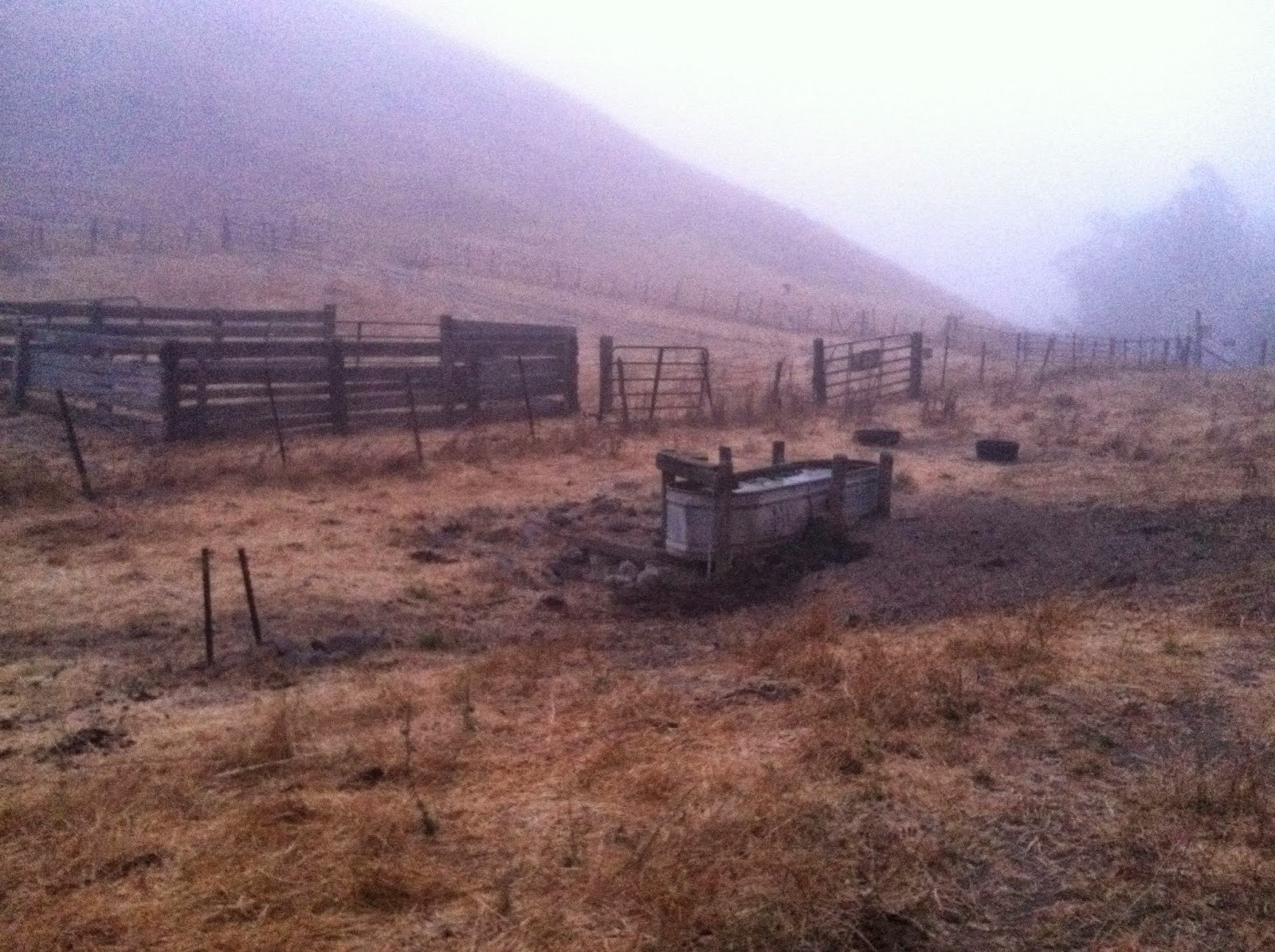
Water trough for livestock
As one can see from these photos we didn't have to fight loud and overcrowded trails all the way until the last section of the trail where it merges with trails from Stanford Ave.
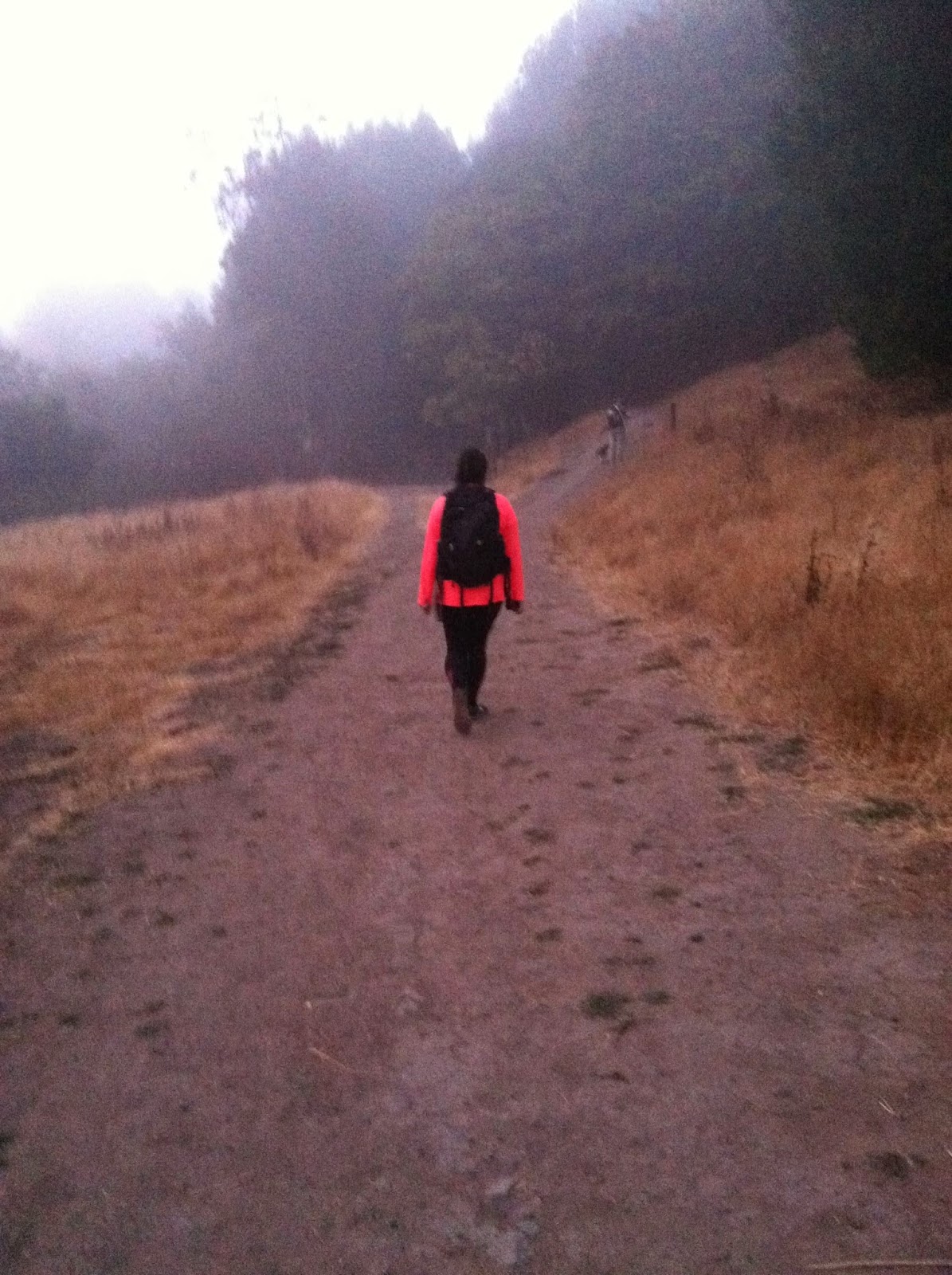
Tiffany on the trail

Mission Peak Trail marker
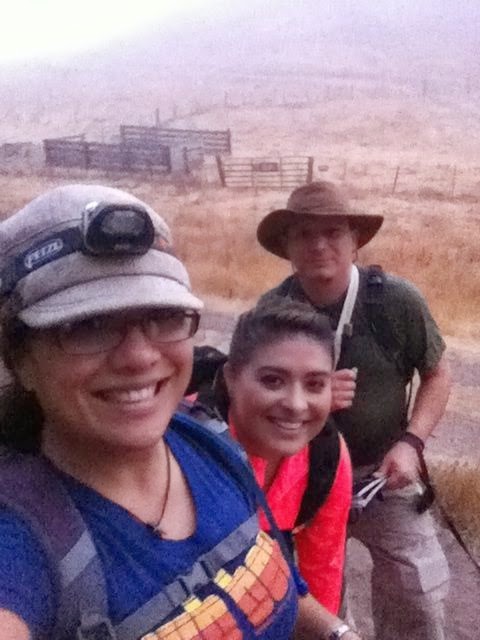
The Gang
 Although the multiple trails and number of other attractions within Ohlone Regional Preserve most of the people in the Bay Area are familiar with Peak alone. Due to this the trail is seriously overtaxed with visitors and hikers attempting to reach Mission Peak and now it's famous (primarily thanks to Social medias such as Facebook, Instagram, Pinterest etc.) peak marker that many hikers climb and pose by for the photo-op. Authorities had to take some serious measures in restoring and protecting the trail and park for future as seen in this video below


This gentleman's video shows how bad the crowds can be during the summer months at this beautiful park:


If you decide on ascending to Mission Peak trailhead starting at Stanford Ave you will be doing it via Peak Meadow and Horse Heaven Trails. We on the other hand used Peak Trail all the way to Mission Peak ascending it from Western Ridge.


 We didn't make it to the top of Mission peak in time to enjoy the sunrise however we did get high enough above morning fog to have a full view of this spectacle.


This early on the trail and we had encountered a small number of hikers and runners on the trail enjoying the early morning and coolness that it had to offer


Lake Del Vale and Livermore were still covered with fog and asleep by the time we reached the top of the hill. Mission Peak Regional Preserve is well connected with Ohlone Regional Wilderness and offers many opportunities for Mountain Biking, Horse Riding and backpacking


Mt Diablo dominates the landscape on the back side of Sunol Ridge and is clearly visible in the background 


Tiffany, Noelle and myself posing for my wife Laurie beside trail with fog bank in the background


Big smiles all around


Sunol Ridge visible on the left of us in the background 


Coffee and snack while enjoying the view


It was all her "Fault"...


... but Noelle didn't care she loved it as long as she was outdoor with us!


Sun is up and we are on the way to the summit, from this point on it will just get hotter and hotter.


Waiting for girls to catch up with us...


...but first lets take a selfie!!


Higher we climb view just gets better and better


Last leg of the climb we had to share the trail with hundreds of other hikers that were on their way up as well. A lot of them didn't look prepared for this climb at all, we noticed many of them were in inadequate footwear caring no water or at the best caring a small bottle that at that point was mostly empty. The trail looked damaged and there was a lot of trash that people left behind them, despise the fact that Park Crew had placed and were maintaining the large number of Trash Cans. Certain sections of the trail were 25 feet (7m) wide without any apparent reason other than carelessness and disregard for eco-system.


There were a lot of other dogs besides Noelle walking up the trail, and that was another problem, many pet owners were not cleaning after their pets or even worst they would collect waste in to plastic bags and then dispose them in nearby bushes.


The crowd was worse at the top!! We had to wait in line to get our photo at the peak marker. Some girls actually brought their high heels shoes just to take funny photos in them at the top


Noelle was just happy to get all kinds of petting from bystanders in the line 


Not necessarily the best moment at the trail but well worth it of Photo opportunity 


Like I said it was well worth waiting for. Unfortunately you can see that a lot of visitors come up to the top armed with permanent markers just so they could tag every available surface marking their presence for posterity.


...and Tiff was there to entertain us all with her stunts  


Tiffany sitting at the peak taking it all in planning her and ours next adventure...


My girls posing at the peak playing and enjoying them self...


and my wife Laurie didn't want to be outdone at the stunts so she did some her self.


Some of the livestock that is free roaming the area wondering what is the big fuss about a stick in the ground at the top of the hill...


On our way back we descended down on the Eastern side of the peak and than we use same trails to go back to our car.


One of rewards that we enjoyed at the end of the hike was a nice lunch and coffee at Mission Coffee Roasting Company on Washington Boulevard in Fremont, CA


So typical of kids, she fell asleep in the car on our way home


Overall we had a lot of fun, enjoyed some of most amazing views of Bay Area from the East Bay hills  got some nice photos to share with you all and sore muscles to prove that this hike is rated moderate to strenuous  depending what book you are reading it. One definitely needs to keep in mind that there is wiry little or no shade on the trail. You will need to equip your self with a bag that will allow you to cary at least 2quarts (2 L) of water, plenty of electrolytes  and comfortable protective clothing. Walking sticks of a walking staff is almost a must at the steepest sections of the trail combined with adequate footwear built for rugged and steep terrain 

Dear reader if you by any chance become inspired by this article and embark on your own adventures hike to Mission Peak, please keep in mind that you could become part of solution rather than part of problem. Please observe all rules of the trail and follow all of the instructions given by the Land Managment whom ever that might be. Enjoy the present but keep in mind the future what your actions might invoke in others.

City of San Jose moving in right direction - Our beloved City is becoming people friendly


INVESTMENT IN INNOVATION: KNIGHT FOUNDATION SUPPORTS EXPANDING GREENTRIP IN SAN JOSE


What could developers do with $2.4 billion and more space? What could families do with another $8,000 in their pockets? How many more parks, plazas and bike lanes could a city make if we added more people without all the cars?
These scenarios represent the potential outcome of expanding GreenTRIP in San Jose – a program that seeks a paradigm shift on how we plan and develop.
San Jose is seeking to build another 120,000 homes by 2040, mostly in “urban villages” near public transportation. The city has audacious goals for this growth: to become a greener, more vibrant place that reduces solo driving trips from 80 percent of all trips to 40 percent. It also wants to attract talent that keeps it the capital of Silicon Valley, while remaining affordable to people of all incomes. 
Yet the roadblocks to this kind of future are many and daunting, including outdated codes and expectations that vastly overestimate how many cars people will own and how much they will drive in these areas. Such codes result in huge parking lots that raise the cost of homes, at up to $70,000 per space, and generate more traffic.
GreenTRIP certification helps to shape and build support for residential developments that offer free transit passes, car-share memberships, great bicycle facilities and more. By reducing the need for parking, GreenTRIP lowers the cost of building each unit and allows more space for cafes, parks and other amenities that create great, affordable communities. With GreenTRIP strategies developers in San Jose could save nearly $2.4 billion in reduced costs for parking structures, making homes at many more price points feasible. 
GreenTRIP has certified 17 developments in the Bay Area, with 2,500 homes. It is helping families such as the Lopezes directly save over $3,000 per year with free transit passes, and allowing them to save more by not needing to own a vehicle.  GreenTRIP-certified projects generate nearly 60 percent less traffic, on average, than typical Bay Area homes.

With $100,000 in support from Knight Foundation, GreenTRIP will greatly expand the number of certifications in San Jose, and launch a new platinum level that will encompass new strategies, such as on-site bicycle sharing with free memberships for residents. 
Knight funds are also expanding a GreenTRIP research project that is collecting data on vehicle ownership in homes near transit. This information will soon be put into a database to help make the case for parking reductions, a project supported by three city of San Jose department heads.
“With support from GreenTRIP we can lower the cost of housing by not building excess parking, while supporting more walkable, urban, transit-oriented communities. By making homes more affordable, families of all incomes can have access to opportunities and help keep San Jose diverse and vibrant,” said Leslye Corsiglia, director of housing for the city of San Jose.  
Knight Foundation will also support GreenTRIP with an additional $25,000 if we can raise the remaining funds for the GreenTRIP Connect Tool by May 1, 2015. Designed to unleash the power of GreenTRIP at a broader scale, this online tool would allow all users to identify a particular parcel of land for development, see the benefits of locating near transit, and use toggles to instantly show how those benefits are expanded by providing trip reduction strategies and homes affordable to a range of incomes. It would provide information in a way that can empower community members to engage in decision-making and could ultimately be adopted in city codes, in San Jose and beyond.
By simultaneously reducing the cost of both housing and transportation, GreenTRIP is one way of moving toward economically integrated neighborhoods, avoiding displacement of existing residents, and creating a vibrant and greener city that attracts top talent.
This blog post originally appeared on the Knight Foundation's blog under the title "GreenTRIP: An innovative way to grow in San Jose" by Stuart Cohen and Ann Cheng.
To read original blog post on Transform follow this link http://www.transformca.org/transform-blog-post/investment-innovation-knight-foundation-supports-expanding-greentrip-san-jose

Monday, July 28, 2014

S24O - Sanborn County Park - hidden gem in Santa Cruz Mountains

So here we are doing it again!! 


Gear loaded and ready to roll


Laurie and I finished our second S24O, this time we visited another beautiful County Park near our home. We enjoyed our visit to Sanborn County Park, but then what is there not to enjoy, Big Redwoods, shaded canyons, free hot showers, close proximity to our home, just the right distance to ride! This place has it all and to think of it, that it was always there and yet we "just" discovered it makes it that more exciting. In true tradition of S24O we departed from our home on Friday evening right after we got home from work.  Our camping gear was already packed up during previous days, so all we had to do is change our work clothes load up our panniers on to the bikes and ride. Half  way we stopped for dinner at a local restaurant, and afterwards we continued on our way up toward the Santa Cruz Mountains above a small but affluential town of Saratoga, CA. Decision to ride late in the evening was based on pure pragmatic fact that we were going through a Heat Wave, and temperature was still in the high 90's around 21:00 (09:00PM).  The ride it self was not to challenging until the last mile, Sanborn Road has a 9.5% incline, that required us to walk our bikes for that whole stretch up to the entrance of the Park. By the time we reached our designated campsite it was well after 22:30 (10:30PM) and the heat was still not releasing its grip on Silicone Valley. We quickly set up our camp and made some tea to refresh us, after which we went for a cooling shower. 

Preparing our tea using Trangia stove


We fell asleep quickly listening to a small brook babbling over the moss covered rocks in a steep canyon underneath our camp site, and a quiet whisper of ancient redwoods. The night was so hot that we ended up partially removing the rain fly to improve ventilation.

Despite severe drought in California this little brook was running


We woke up with the sunrise and were greeted with a first glance at our location, our camp was perched directly above a canyon that had a small creek running at the bottom. Despite severe drought in California there was plenty of water running over the rocks producing a wonderful ambiance.


Our Camp site was sandwiched between #17and #19 with a little room to spare


If you are looking for more of the privacy I would recommend site #19 which also provided a larger setup spot for a tent(s) and hammock, as well as it was further away from any other campers. Please keep in mind that our neighbors were extremely courteous and quiet so the close proximity was not a big deal at all.

First task of a day...Coffee making


We quickly set in to our morning routine, making fresh coffee & breakfast as well as taking a lot of photos and scouting the park for all of the hidden gems that we wanted to learn for our future visits

Laurie posing with our "kitchen" gear before her on the table

We often get asked what kind of gear do we take on our S24O trips, how much of it, how much food we take... so in this post we will elaborate about our "Kitchen" Kit. It is basically a slightly modified kit that we normally use for Backpacking or a longer hikes. We use a Titanium pot with Lid from Snow Peak in which we store our Swedish Trangia Mini Alcohol Stove that we removed from a kit that was purchased at REI. We seldomly find a use for pot and lid that was included in the original kit, however stove and a pot stand is a standard part of our kit. We also added a Alu-Foil Wind Screen to improve fuel consumption and speed up the boiling.


This is all kitchen gear we need for a great S24O
We also included Swedish Fire Steel from Light my Fire for the easiest fire starting, Pack' n Eat Mess Kit by Light  My Fire that we modified by using only the Lid = Plate, Bottom = Bowl, Cutting board. We didn't find much of use for small containers, Spoon/Fork combo or a Cup that come with original set due to simple preferences. We augmented this mess kit with Titanium Spork(s) by Snow Peak,  Folding Cups by Coghlan's, Opinel Carbon Steel folding knife and a Pop-Up Sponge by Trader Joe's that we cut in half since we don't generally need the whole thing and it stores smaller.
Also since we are just like any other cyclist, we value our coffee, so to make coffee preparation a breeze we use a 32 oz. Wide Mouth Water Bottle by Nalgene and a aftermarket French Press by Press-Bot that converts your 32 oz Nalgene in to a gourmet coffee French Press!! We are also using Insulated Bottle Cozy by Outdoor Research to keep your Java hot and prevent you from burning your hands while pouring your cup of coffee.
Among other things that we found to be useful are a Frisbee that we use as a serving plate, wash basin, a plate, etc. Small containers for sugar and coffee, a small lunch bag that we carry all of our Freeze Dry food, tea bags, fruits, Peanut Butter Pouches, Spices, Mini Moos Creamers, Clif Bars, Electrolytes, Raw Oats... Clean Kanteen 16oz. insulated bottles, Clean Kanteen 27 oz water bottles, GSI 32oz. Stainless Steel Wide Mouth Bottle, 16oz. bottle for Denatured Alcohol that we use as our fuel for Trangia Stove.


If camping in summer mosquito nets are must!
Time for second coffee & breakfast 
View from our tent
Breakfast of Bike Champions